Frequently Asked App Questions
Why so many permissions?
Collecting location-tagged bluetooth data while the screen is off requires sensitive app permissions that are blocked by default. Each of these permissions must be separately requested by the app, causing the OS to display separate popups for explicit approval by the user. The app cannot run without all these permissions. If they are not granted after the first request, the OS will prevent the app from ever asking again. If this happens, it's easiest to remove the app and then to reinstall it for a fresh opportunity to accept all permissions. The alternative is to dig through your phone settings to enable everything the app requested, but that can be challenging.
Why are there gaps in my data?
When you don't open the app often enough, your phone OS kills the the app to preserve phone resources such as battery life. Android and iOS will monitor how frequently you open the app, especially after you first install it. If the OS decides you don't care about the app, it will reduce how frequently it's allowed to check the sensor in the background, and it will eventually prevent the app from running at all in the background.
To keep the app running reliably in the background, you must open it several times per day, and at least once each morning. If the OS allows, airCoda will run aproximately every 5 minutes 24x7 to collect geo-located measurements from the sensor.
How to change units from percent exhaled breath to CO2 ppm?
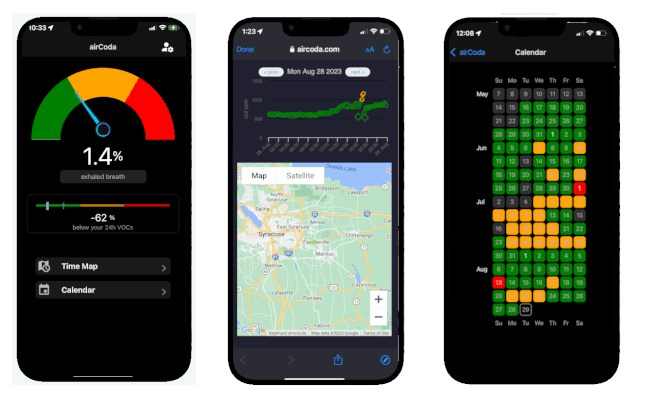
Below the gauge, press the grey button displaying units as "exhaled breath" to toggle back and forth between the two units.
What are the small dots on my day-map chart?
If the app does not find your selected airCoda sensor, but finds another sensor in its vicinity, it marks the data as "other" on the gague screen, and plots this value as a smaller dot on the graph. VOC data from "other" sensors are not plotted, because their 24-hour baseline will not be comparable to that of your own selected sensor.
You may also notice some points rendered as a small bulls-eye. These points were captured while your app was open, rather than from the background.
How to show the map in satellite mode?
Touch the bottom left corner of the map (near the "mapbox" logo) to toggle between the default map mode and satellite view.
What are the colors on my calendar?
These represent the the top quartile of CO2 levels for each day. If one quarter or more of CO2 measurements for the day were in the yellow range, that day is represented as yellow.